History of Mapping Hong Kong
Introduction
The early mapping of Hong Kong was undertaken as part of the navigational charts, examples of these can be found at the
Hong Kong Maritime Museum. An early example of the mapping of Hong Kong as recorded on the maritime chart from 1749 is
shown here.
The early topographical mapping of Hong Kong, can best be described from an article in the Hong Kong Naturalist from 1932.
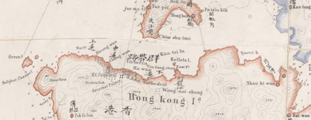
Shortly after the acquisition of Hong Kong Island, in 1842 a survey was undertaken by the Royal Engineers.
The map produced was on the scale of 4 inches to the mile. It was dated 1845,
and bears the name of Lieut. Collinson, R.E. It was, till 15 or 20 years ago the only available survey map of the Island.
At the time this survey was made there was little
else to show on a map of the Island but the hills and water-courses. The hills were shown by contours 100 feet apart,
these are of a limited degree of accuracy—probably sketched on. The development of the Island soon put this map out
of date and it is now only of archaeological interest, but as such should command a place in the City Hall and in the Land Office
The growth of the City of Victoria soon produced a demand for a map on a scale large enough to show the different properties and streets.
This map was made on the scale of 160 feet to the inch and from 1860 onwards passed through several editions.
One of these editions contained some amusing errors, " Cricket Grey Lion " for " Cricket Pavilion," " Cleanse skin "
for " Gleneskin," " Cows Nest " for " Crow's nest " a parallel no doubt, to the Chinese system of translating a foreign
name into the nearest Chinese sounds. Across the water, Kowloon Peninsula was not acquired till 1860, and so was not
included in the Collinson survey. In the eighties or nineties of last century when the development of the Peninsula had
commenced and public works were contemplated, a survey of this district was undertaken by what was then known as the
Water and Drainage Department (since merged in the P.W.D.). A good map was produced to a scale of 1/2500 (208 feet to the inch).
Continued building development on the Peninsula soon put this map out of date, and it was followed by a new map,
produced by the survey branch of the P.W.D. on the scale of 200 feet to the inch. Contours were not shown on either of these maps,
and, considering the way hills are removed and holes filled 'in at Kowloon, contours would be of no permanent value as
showing the topography. The New Territory was leased in 1898. Before that date the only available large scale map of the district
was one made by Italian missionaries. This map was on the scale of 1 inch to the mile. The outline was taken from British Naval
Charts. It covered the whole of the San On District, thus including Hong Kong, the New Territory and a considerable area to the north.
It was printed in English and Chinese. Several of the villages were out of place and the physical features were poorly shown,
but it was a useful map in its day.
On the acquisition of the New Territory, one of the first undertakings of the Government
was the making of a survey of the district. It was to be mainly what is known as a "cadastral" survey i.e. a
large scale survey of occupied land for the purpose of fixing its ownership and as a basis for taxation.
The detail field work was done by Indian Surveyors under the
guidance of two European officers, supplied by the Survey of India. When
this Cadastral survey was completed it was thought that a topographical
map should also be made. The proportion of cultivated land in the Territory
(about one-sixth of the total area) was so small that the cadastral maps
showed large blank spaces between small patches of surveyed land. These
blank spaces however were to some extent occupied by trig, stations, and
with their help the intervening hills were sketched in. The map produced
Was on the scale of 2 inches to the mile. The hills were shown by contours
100 feet apart. These contours were sketched in between the few trig,
stations on the hill tops and the patches of cultivated land in the valleys.
The result was a map of varying degrees of accuracy. In places where the
valleys were straight and the slopes uniform the work was easy. But in
the jumble of hills and valleys (pays accidente is the very expressive French
term), which makes up the greater part of the Territory the work was difficult
and the map produced was in places so inaccurate that when the
Geological Survey was undertaken a few years ago, the Canadian geologists
in charge of that work were often unable to fit the geological features onto
the topographical map. As an instance of this inaccuracy, it may be mentioned
that the island of Chu lu kok (Chik lap kok) north of Lantao, is
shown by the contours as 1,000 feet high. It should be 500 feet.
The Military Authorities found this map inadequate and commenced
a survey of the southern part of the Territory and issued a contoured map
on the scale of 2 inches to the mile. This map was first published in
pre-war days [Dated 1915]. Its later editions included Hong Kong Island, most of Lamma
Island, and the mainland as far east as Port Shelter and as far north as
Tai Po and- ended westward a few miles beyond Tsun Wan (Tsung Wan).
A marginal note on this map tells us that the contours on the mainland are
surveyed, those on the islands "approximate only." Hong Kong is an
island and a patch of about half a square mile to the south of Butterfields
reservoir is certainly a good example of this "approximate" work. Neither
the hills nor the valleys can be identified on the ground. The mainland
part of the map appears good work. It is a curious anomaly that Hongkong
Island the most important part of the colony should be the worst mapped.
The great war stopped this work but brought out the method of
aerial surveying and in 1924-1925 aeroplanes were at work taking the necessary
photographs for a new map. The result of this work is a map of
Hong Kong and the leased Territory on the ample scale of 1/20,000, nearly
3 inches to the mile with contours at 10 metres apart.
The Survey and Mapping Office of the Lands Department provides a more succinct account when describing the history of the Hong Kong coordinate system.
Triangulation stations first appeared on the map of Hong Kong produced in 1845 [the Collinson map].
A map was produced by Mr. Tate in 1899/1900 and another one was compiled by Mr. W. J. Newland in 1903/1904. Although
triangulation stations are shown on these maps, there is no survey record found for the triangulation.
In 1928/29 a military map of scale 1/20,000 was produced from air photographs taken in 1924/25 by the R.A.F. with ground
controls provided by the 2nd Colonical Survey Section R.E. These ground controls were adjusted by the Geographical Section in
1928-30 and were later re-adjusted by the Crown Lands and Survey Office in 1946. It was adopted as the Main Triangulation of
Hong Kong on which all surveys were based up to 1963.